China infrastructure build up seen on imagery in Ladakh
The Chinese PLA continues to build up infrastructure along the Line of Actual
Control (LAC) even after both India and China agreed to disengage from key
areas in Eastern Ladakh. That this process has been ongoing reflects Chinese
intent towards India despite engaging in several rounds of military level
discussions over disengagement from the points of tension that occurred in
the stand off in Eastern Ladakh last year. The build up by the PLA has been
observed since the start of the year and most recently through satellite
imagery in August 2021. Tensions have again flared up with the extension of
the Tainwendian Highway leading upto the Depsang plains just 24 km away
from India’s highest airfield, Daulat Beg Oldie (DBO).
Satellite images dated 17 August 2021 have revealed upgraded infrastructure
near the Depsang Plains along the Western sector of the LAC between India
and China. According to the twitter handle @detresfa_, the Tianwendian
Highway that leads up to the Depsang Plains area under China PLA’s control
in Aksai Chin has been undergoing roadworks, widening and upgrades this
year. This handle has released numerous images since tensions between India
and China began building in May 2020. The Highway connects the PLA’s post
in Tianwendian in Aksai China to the Depsang plains. The Tianwendian
highway connects the PLA’s Tianwendian all-season post in Aksai Chin to the
Depsang Plains. The post is situated barely 24 km from DBO.
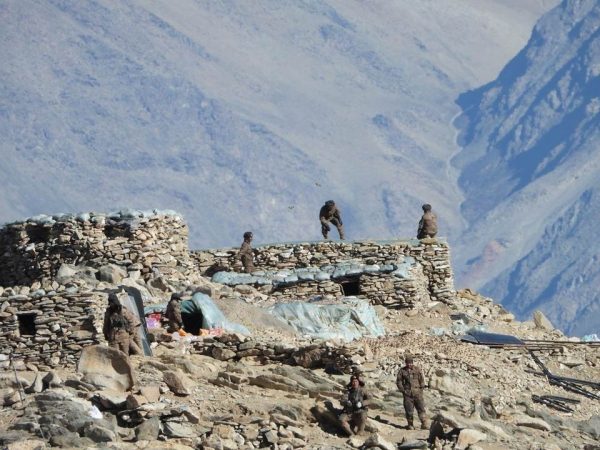
During the current standoff, Chinese troops have brought in their tanks and
troops close to Indian positions. The Tianwendian post with its air defence
systems, storages, additional shelters and vehicles for the reinforcements
serves as the core of PLA operations. The images below, published by India
Today, are night images of the Tianwendian Post with new structures. The
main double-storey building at the post now is surrounded by several
temporary camps and shelters.
The post initially had three large buildings possibly for accommodating a large
number of troops; however, the facility seems to have been expanded to house
additional PLA troops during the standoff period. Temporary shelters with
defensive walls as well as observation posts are also visible in the new
imagery. The image below gives a closer view of the new buildings.
After initial breakthrough in Pangong, the focus of the negotiation is on
Depsang plains where China has come in around 18 km since 2013. DBO is
barely 20 km away from the Karkoram Pass. Depsang plains are also close to
China’s western highway G219. Depsang at 16,000 feet north of Shyok River
is strategically important as it provides India, the Daulet Beg Oldie airstrip
and Karakoram Pass further north.
Indian patrols have been blocked here by PLA in the Y junction area as the
Chinese have intruded 18 km inside since 2013. (See image below) In April
2013, the PLA had set up a temporary camp at the mouth of Depsang Bulge,
where the Raki Nala and Depsang Nala meet, claiming it to be Chinese
territory. However, after a threeweek standoff, they withdrew as a result of an
agreement with India.
Regular patrols to patrol points 10,11, 11A, 12 and 13 have been blocked due
to the impasse. India has been asserting that not just Pangong but all friction
points across Eastern Ladakh including Depsang and areas around Demchok
where Indian grazers have been obstructed should be dealt with. Chinese
troops have been blocking Indian patrols from proceeding along the Raki Nala
valley near the “bottleneck” since 2017. After a resolution to the standoff at
Pangong Tso in February 2021, it was reported that the Chinese had started
strengthening their positions at Depsang. The Indian military’s Sub Sector
North is east of Siachen Glacier, located between the Saser Ridge on the
south-eastern side and the Saltoro Ridge on the Pakistan border.
Despite the talk of disengagement, the Chinese are clearly asserting their
military control over Aksai Chin. In particular, the focus on Depsang Plains
is of concern because it is very close to India’s DBO and Karakoram Pass.
Given this situation, the direction of further disengagement talks with China
at the military level will have to very carefully calibrated and attention paid to
the build up across the LAC. If this is not done, the likelihood of India being
tactically disadvantaged in the Depsang Plains is possible. More importantly,
it sends out a signal that China is preparing for a long haul in Ladakh,
another aspect of China’s military planning which requires closer scrutiny.