Is Gwadar’s New Development Prepared to Handle Its Weather?
Gwadar often sees intense seasonal rains that can cause flooding. Recent CPEC-linked development in the rapidly growing city may be making that problem worse.
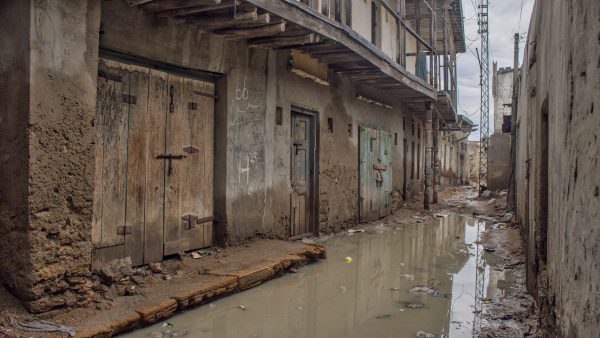
In Gwadar, a coastal city in Pakistan’s Balochistan province, seasonal downpours usually arrive in winter. The intense rain does not stay for long – only a few days a year. But even this short period often floods the entire city. This year, ocean-going boats were floating down streets in the old neighborhoods of Gwadar, helping women and children escape the several feet of water.
A little further from these old neighborhoods, just before turning to the road that leads to Gwadar port – the gateway to China’s ambitious China Pakistan Economic Corridor (CPEC) – at Mullah Moosa Mod, a few men dug at both ends of the road, making large ditches for the floodwaters to flow downward to the ocean.
While rains are one of the most important sources of water for dams, they often also leave Gwadar sinking. This has happened before: in 2010, 2007, 2005, and so on. But when parsing why Gwadar floods, we have to ask: Is it the rain that is the problem, or flaws in the planning and development of Gwadar’s rapid changes?
In the last two decades, infrastructure development has been a priority in Gwadar. Much of this work is undertaken by Gwadar Development Authority (GDA). Established in 2003, the GDA is a government sector corporation responsible for implementing urban development projects in Gwadar district.
Diplomat Brief Weekly Newsletter N Get briefed on the story of the week, and developing stories to watch across the Asia-Pacific. Get the Newsletter
In 2005, the GDA introduced Gwadar’s first master plan. This plan merged the port with the old neighborhoods. The population of these areas had to be resettled in the north of the town. Part of the plan was implemented during the construction of the first phase of the port, where the southern-most edge of town made way for most of the port area.
Enjoying this article? Click here to subscribe for full access. Just $5 a month.
But most neighborhoods – including Shahi Bazaar, one of the historic sites in the heart of Gwadar – did not experience much change. For years, the area did not experience any development, nor did the planned resettlement take place. These densely-populated neighborhoods are a world apart to the dedicated port area not too far from them.
Over the years, local communities campaigned against the resettlement plan and the government’s negligence toward any development work in the area. Eventually, the government had to change the plan.
In 2019, the new master plan promised to include the old neighborhoods in the development work, allowing the population to live in the area. Shahi Bazaar was recognized as an important historic site to be renovated without changing the old structures.
While the GDA has launched an official website, there is not much information about the ongoing or completed projects. Living in the town, one can see a number of new roads and a lot of construction constantly in process. However, locals have concerns about both the quality of the work and the location – where, exactly, the development work is happening.
In terms of quality, many of the roads and pavements constructed a few years or months back are easily damaged after only a day’s rain. Part of the reason is the lack of a proper drainage system. Without that, rainwater tends to collect and pools on these surfaces, damaging the roads as well as burdening the economy with the need to fund machinery and tankers to get the excess water out of the roads.
“An important solution to save the roads from damage and water collecting is using one of either two most common techniques: culverts and road drainages,” explains Sameeh Baloch, a local engineer. “In simple words, culverts are pipes installed beside or under the roads. They can be installed in places where the road is higher than the ground so the water easily flow downwards through pipes into the ditches at the road side. While this technique is used in some places, the center of Gwadar town is very congested, but this technique does not work there. So there are drainages as part of the sewerage network.”
But despite the use of drainage networks, in most of the city, rainwater still has to be removed from roadways by tankers.
While the GDA so far has not worked on the sewerage and drainage network in the main town, the local government has. The project failed to solve the problem, but instead contributed to more damage.
Since the center of Gwadar is lower-lying than the surrounding areas, excess water does not naturally flow away from the area. Instead, water keeps overflowing in the area on a daily basis – even without any rain. In a related problem, many roads and pavements constructed by the GDA are easily damaged and this necessitates more construction work at the same spot again and again.
“A problem with the GDA’s projects is that they are often implemented through consultants who are very influential people and have complete authority over what projects the GDA includes in its plan,” explains Nasir Rahim Sohrabi, an activist and president of a local development organization. “The same goes for the contractors: they have longstanding relations with the officers and consultants, so they bag the projects and have authority over implementation process. Altogether, there is the issue of transparency and credibility in all the processes.”
Enjoying this article? Click here to subscribe for full access. Just $5 a month.
In 2010, Gwadar was badly hit by Cyclone Phet, which was estimated to be four to five times worse than the storm earlier this year. To get rid of the rainwater at different spots, local people dug along the roads to let the water flow to the ocean. In 2022, after 12 years of development, trenches were again dug at the same spots to make way for the water.
Similarly, in 2010 water tankers employed by the local administration and the GDA pulled water out of the streets; the same technique was used once again this year. Thus, even 12 years later Gwadar’s urban development is still unable to handle a flood-like situation – let alone an actual flood.
To make things worse, in 2018 the government planned the construction of East Express Way as part of CPEC’s “early harvest” projects. This is a nearly 19-kilometer, six-lane expressway that provides a direct link for cargo traffic to and from Gwadar port.
Initially the design entirely blocked the ocean off entirely from the east part of the town. Thanks to the fishers of Gwadar, who stood up for their right to fish, at least three underpasses were included in the plan, to be used by the fishermen as access points for fishing. These underpasses, however, have a much more crucial role than just serving as access points for fishers. The eastern part of Gwadar has a lower elevation as compared to the west. Thus, rainwater for the east part of the town naturally flows to the ocean. If the Express Way cuts off that natural water flow pattern, it would exacerbate flooding problems.
As noted before, the surface level in the center of Gwadar is lower than the eastern and western parts of the town, making it the most vulnerable to flooding. The sunken nature of the central part of town makes natural drainage almost impossible, and therefore the drainage network of the local government failed.
“With proximity to the sea, poor absorptive capacity of soil, topped with a poor drainage system, the flooding of town after rains and overflow of drainage on streets will continue,” explains Pazeer Ahmed, a geologist and researcher from Gwadar. “We need a participatory approach [to development] that includes masses, important stakeholders, scientific planning, and effective management of plans and projects from government. Without this, it is impossible to fix any of the issues with flooding and drainage.”
Understanding the geography and climate conditions of a region is an important part of urban development. With thoughtful urban planning and development, many disastrous situations and economic burden can be avoided. On the other hand, the lack of such careful planning raises important questions.
If Gwadar city is being developed for the long term support the port and CPEC, why is there no quality control and transparency with infrastructure development work? Without getting the answer to this, it is difficult to determine if Gwadar is actually being developed into an economic powerhouse for the next few decades for both Pakistan and China.